


After six and a half years at Microsoft, my role was made redundant as part of the global restructuring the company undertook and you can read my initial reflections on this experience here. I was fortunate to secure a new role quite early on after my redundancy and negotiated a delayed start date to allow for a break and I was keen to do some more bikepacking after my experiences in December and January in the North Island and also completing the West Coast Wilderness Trail with a couple of mates in February.
This will be a summary of the journey and, given it was ten days, I’ll break it down by different sections if you want to skip ahead. Broadly, I’ll include the route, some photos/video and some reflections for each day.
The Redundancy Ride – Christchurch to Oamaru via the Alps 2 Ocean Route
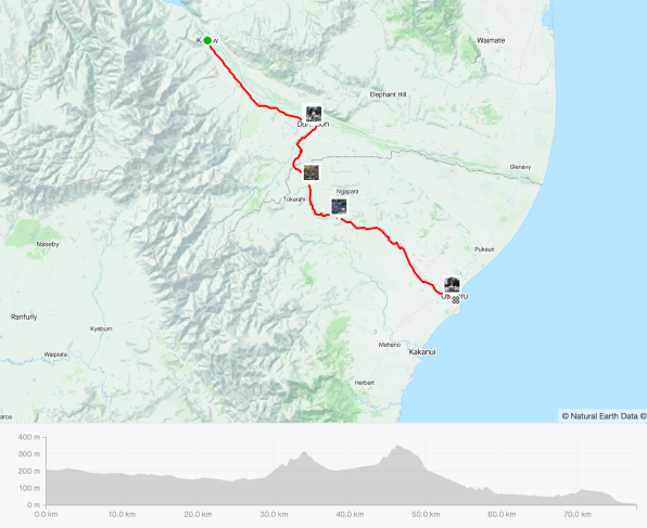
I created my own route to Lake Tekapo but from there followed the Alps 2 Ocean route to Oamaru.
- Day 1 – Christchurch to Glentunnel
- Day 2 – Glentunnel to Methven
- Day 3 – Methven to Geraldine
- Day 4 – Geraldine to Lake Tekapo
- Day 5 – Lake Tekapo
- Day 6 – Lake Tekapo to Twizel (A2O route)
- Day 7 – Twizel to Omarama (A2O route)
- Day 8 – Omarama to Kurow (A2O route)
- Day 9 – Kurow to Oamaru (A2O route)
- Day 10 – Oamaru (and home)
- Final Reflections
If you’re in the TLDR mode (Too Long, Didn’t Read) then hopefully the gallery of images above and this video give you a good impression of the trip:
Day 1 – Christchurch to Glentunnel
- Moving Time: 3hr 05min
- Distance: 66.01km
- Elevation: 286m

In some ways, there was not a lot of planning to this trip – I knew I wanted to get on my bike and ride, but the exact destination was unclear. On top of this, we had spent a week in the North Island visiting family over the ANZAC weekend so I was going to have a very short turn around time between returning home and heading off. Here are a couple of photos from the North Island before we returned home:


Getting ready to board the ferry to cross Cook Strait:


Knowing that I wanted to stay off SH1 completely, and avoid busy roads wherever possible, I followed the guide on this site and headed towards Glentunnel a delightful dot on the map with a beautiful camping ground.

This photo was the bike all backed and ready to depart – it didn’t take me long to pack everything up, although given I was not rigorously following a gear list, I did forget the charger for my Shokz bone conduction headphones. Fortunately, I remembered 5km after leaving home and my wife drove and gave them to me! The weather was fine, the sun was shining, there was a slight tail wind and the open road beckoned – I could not have been more excited to be off on my journey:


Routing took me down a mixture of quiet country roads and great gravel bypasses and very few cars passed me at all. As I was approaching Glentunnel I passed the Coalgate Pub and made a note to head back to watch the rugby that night! Soon I was at camp and setting up the tent for the first time:

A few minutes after arrival, a couple in the caravan on the right in the image above invited me over for a drink and a chat which was lovely to talk with them and then I biked the 3km back up the road to the pub and watched the rugby – the Crusaders narrowly losing to the top of the table and undefeated Chiefs!

With the game done and a quick ride back to camp, I was in bed and excited the trip was underway!
Day 2 – Glentunnel to Methven
- Moving Time: 2hr 33min
- Distance: 43.29km
- Elevation: 466m

Day 2 dawned with more beautiful weather and, after packing down the tent damp with a heavy dew, I was soon on the bike. I have to admit the legs felt heavier than I expected after a relatively easy ride the day before and it was not until afterwards I realised the day was essentially a slow uphill climb most of the way right from the start. Clearly, I’d been spending too much time on my eBike and not getting enough ‘real’ cycling miles in before starting this trip! Nevertheless, the scenery was beautiful and I had one moment where a curious native hawk followed my progress for a couple of minutes, hovering and gliding 50m or so in front of my bike following the road I was riding.


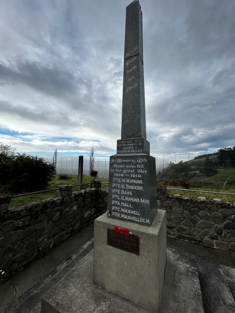
It was not long before I came across a beautiful memorial to the local men that had fought and died in WW1 and WW2. As I would for the remainder of the trip when I came across these, I stopped and took a photo and reflected on the terrible impact war had on the local communities. With the mountain ranges in the background, it was a beautiful and reflective place:


Not long afterwards, I approached the Rakaia Gorge. There is a nice, flat and long bridge on SH1 crossing the Rakaia River further towards the coast, but I’d hate to ride across that (not sure it’s even legal) and so the only alternative is to go via the Gorge – a scintillating ride down and a slow grind up and out. As I learnt, it’s a place steeped in Māori history where they believed a taniwha (water spirit/monster) lived. Here are some shots looking down towards the Gorge and the river itself:


My bike on the narrow bridge crossing:

On the climb out of the Gorge there were some great signboards explaining the Māori history:


Whether it was the steep climb out of the Rakaia Gorge, the not-great first sleep in the tent, or just general fatigue from a busy week away in the North Island, I was not feeling like pushing on to Geraldine as I’d originally planned. Given I was on my own time and schedule, I decided to stop in Methven for the night, having only done a half day of riding – perfect! Getting to campsite early meant I could dry the damp tent and also air some of my clothes before wandering off to the Methven township for a late lunch.


I ended up eating at the historic Methven Blue Pub which, I subsequently learned from my dad, was once owned by my great grandfather Patrick McNeill who emigrated from Ireland to Methven/Lauriston region:

After lunch I took a stroll around town and ended up having an early night anticipating the ride down to Geraldine, one of my favourite small towns.
Day 3 – Methven to Geraldine
- Moving Time: 3hr 16min
- Distance: 76.09km
- Elevation: 102m

Rising early, I cooked one of my camp meals in the kitchen – Chilli Con Carne on rice with a hot chocolate to top it off:

It was another awesome blue sky day, a bit chilly to start, but nothing was going to distract from the joy of riding back country roads. I was feeling a little chesty with a cough that seemed similar to what my wife and son and come down with the day after we returned from the North Island so I didn’t push the pace, happy to just ride at what felt comfortable. The fact this was a mostly downhill run to Geraldine certainly made it an easy ride too. In the early going, I could see an ominous line of cloud to the east and when I looked west, I could see the mountains looming in stark contrast:


I remember tweeting the following image and captioning it that the photo didn’t really do justice to how beautiful Mt Hutt and Mt Somers looked in the distance:

The bike was eating up the kilometres and soon I was in Mayfield for an early lunch to keep me fuelled, before I hit the Rangitata River, crossing on a quiet bridge (quite different from the busy bridge closer to the coast on SH1. The Rangitata River is a good example of a braided river which are not that common globally, but very frequent in the South Island of New Zealand.


After crossing the river, I had a decision to make as to whether to turn west and head to the Church of the Holy Innocents near Peel Forest which I was interested in as the prolific detective novelist Ngaio Marsh is buried there. In the end, it would have added around 35km to the journey and given my chest was feeling a bit tight from the infection and it was only day 3 of the trip I decided not to – another reason to return on a different day!
Pushing on, I was soon in Geraldine and I opted for a cabin instead of using my tent at the holiday park, figuring a sleep in a bed might get me feeling better and not letting the cough really set in. I love the buildings around Geraldine, it has such a beautiful feel to it:


Airing my tent to dry, I took a walk along the “River Path” – this is what I love about bikepacking, it allows you the time and space to do and see new things. I had spied this when I crossed the river coming into town, something I’d always missed when in a car, so I was able to walk down there from the campsite before dinner and admire the Autumn colours:
The River Path was a place of peace and tranquility and I really enjoyed my saunter through there.


Day 4 – Geraldine to Lake Tekapo
- Moving Time: 5hr 37min
- Distance: 90.02km
- Elevation: 1,194m

Day 4 ended up being both the longest and one of the most enjoyable days on the entire trip. I’d previously biked from Fairlie through to Lake Tekapo in 2020 on my eBike so had a fair idea of what to expect, but of course it would be a different experience without any power assist! Having stayed in a cabin I had a better sleep but was still a bit chesty, and with pink sky in the morning was it going to be a case of shepherds’ warning for bad weather ahead?


The gradual uphill climbing began almost immediately, and there were wispy bits of cloud/mist in the air as I wound my way through the countryside and the occasional stunning autumn coloured tree:


At the top of one climb I came across another memorial to the local men who had fought, served and died in WW1 and WW2. On the surface of it, it appeared to be in the “middle of nowhere” and I used to wonder why these were positioned where they were. It dawned on me at some point that far from being in the middle of nowhere, they were in prominent positions on main roads so they would be seen frequently as people travelled through the region, a permanent reminder of the sacrifice of others. With the cloud in the valley below, the monument had a haunting effect when adorned with recent poppies from the ANZAC day celebrations the week before:


After a further short push to the summit of Hilltop View, I was in the McKenzie Country and looking down into the valley with Fairlie (and lunch!) beckoning!


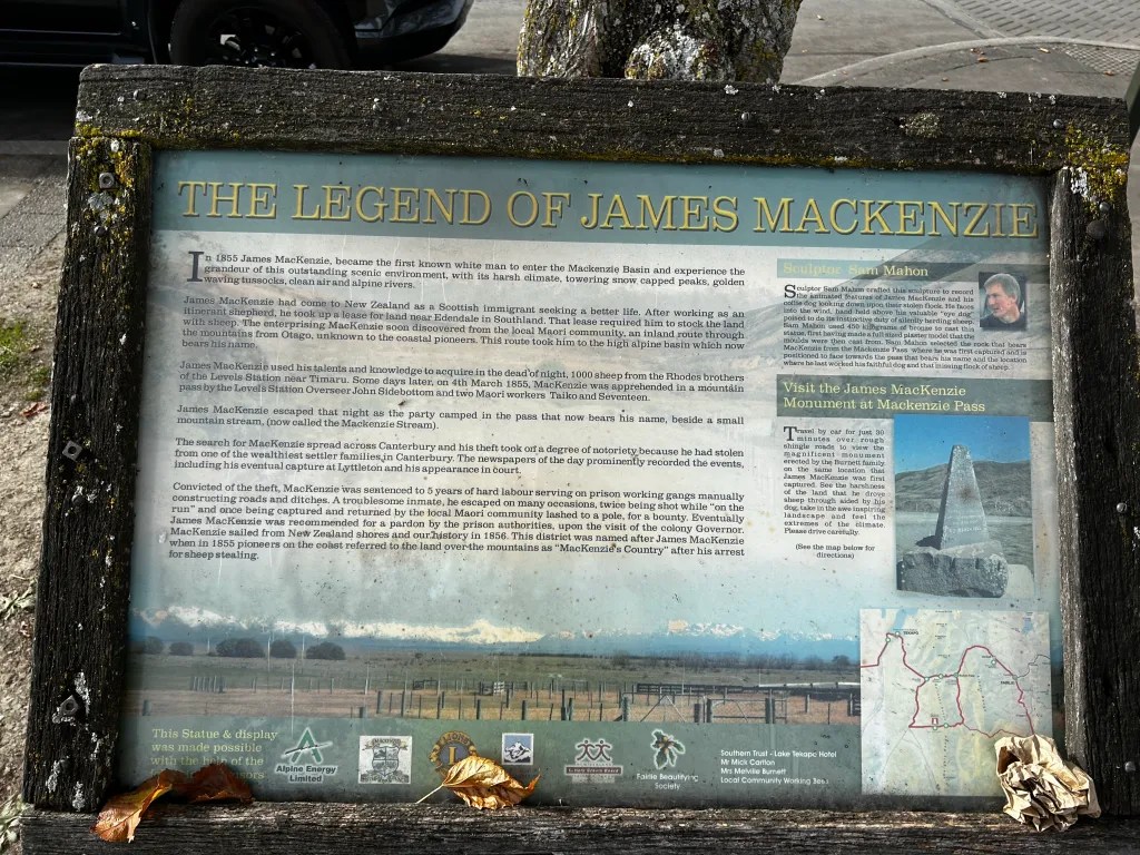
I decided to actually ‘enforce’ a longer break over lunch, with the plan to spend at least 45mins resting and so I had some food and sat next to the memorial/statue of James McKenzie, a colourful character from around 1855 who allegedly rustled 1000 sheep and took them through an otherwise unknown pathway into a valley known only by local Māori (this would subsequently become known as the McKenzie District). His history is cloudy, but he holds a special place in New Zealand history:

Exiting Fairlie it’s impossible to miss their impressive memorial to their war dead:

Equally impossible to miss is the “Peace Avenue“, 500 Oak Trees planted on the way from Fairlie to Kimbell that were planted in honour of the signing of the armistice at the end of WW1. The final hurdle of the day would be Burkes Pass, a significant climb to the plateau before a rapid descent down to Lake Tekapo.
As I approached the hills it was hard to see the path through, but I knew it must be there somewhere!

There was an interesting cemetery that I explored at the start of the climb and also a monument to Michael John Clarke (a graduate of Dublin University) and the first Pakeha to survey the area:


Shortly after, I reached the high point of Burkes Pass at 709m:

With the sun shining and the climb behind me, it was time for some epic scenery to soak up:


I pulled over in the designated sightseeing area and took a short video – sometimes a video does a better job of describing the beauty than photos:
I was enjoying the sunny and unusually warm weather (it was low 20s) and no wind … until a strong nor’west wind came up about 15km from Lake Tekapo whilst I was still on the plateau. It was warm, but the hot headwind was certainly energy sapping at the end of a long day, slowing my progress before I dropped down into Lake Tekapo. My first stop was at the supermarket to get a cold drink and some sushi and then sit beside the lake and soak up the late afternoon sunshine:
I headed to the lakeside campsite and pitched my tent in the gloaming (twilight/dusk) and had a quiet dinner of fish and chips in the dark beside the lake in the warm evening, watching the moonrise over the lake:


Overnight, the wind got up and the rain came through making for a noisy night with less sleep than I would have liked after a longer, tougher day on the bike.
Day 5 – Lake Tekapo
- Moving Time: 2hr 51min
- Distance: 9.61km
- Elevation: 444m

With thunderstorms rolling through in the morning, I decided to have a rest day in Lake Tekapo and move from my tent to a cabin. Once the weather started to settle down I went for a hike around the peninsula and climbed to Mt John Observatory. I saw some incredible rainbows that seemed so close I could almost reach out and touch them:


The pathway was just stunning:


The view from Mt John Observatory was, as usual, fantastic. The route up the hill is a favourite of mine, one I’ve walked in all sorts of various seasons:
As I descended Mt John, the weather was really changing for the better with warm sun coming out and promising great riding weather the coming day:

Day 6 – Lake Tekapo to Twizel (A2O route)
- Moving Time: 2hr 56min
- Distance: 55.92km
- Elevation: 192m

I had a lovely breakfast of pancakes before heading off and taking a couple of photos on the iconic bridge looking towards the Church of the Good Shepherd and then heading off to the canal to follow the route down to Lake Pukaki. This was following the alternative starting route of the Alps 2 Ocean trail that you can read about here.


This morning proved to be yet another day where I saw virtually no other riders, it was almost as if the trails had been closed just for me and it was a simple case of following the liquid blue road south towards Twizel:


The road was a mixture of beautiful gravel and some sealed sections:

At the end of the canal there was a rapid descent down to Lake Pukaki, before following some gentle single track around the lake to the foot where I paused for a cold drink. Unfortunately Mt Aoraki/Cook was obscured in cloud, but the views nevertheless did not disappoint:

Crossing the State Highway, I entered a forest and tussock stretch before arriving in Twizel:


I had a chance to catchup with an old colleague from when I was teaching at Catholic Cathedral College and she is now teaching at Twizel Area School – it was fun to catchup on the news. With an anticipated longer day ahead, I had an early night with the full moon high in a cloudless sky lighting up the inside of my tent like there was a spotlight on it.
Day 7 – Twizel to Omarama (A2O route)
- Moving Time: 4hr 53min
- Distance: 80.68km
- Elevation: 676m
The morning dawned quite different from the evening before when I went to bed. From a clear sky and full moon, I awoke to a thick mist. As I biked into town to grab some supplies for the ride I could see the mist hovering over the school grounds, enshrouding the goalposts and trees:

My tent was very wet with dew, but I nevertheless packed up and headed off. I was very grateful for my high viz vest, blinking lights and Garmin Varia radar to help me “see” behind me and warn of any oncoming cars and pull as hard left as I could. There were some great images as I followed the canal, including a small island on Loch Cameron:


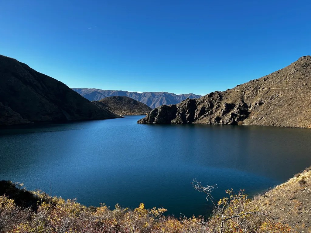
I was hopeful the mist would rise as I approached Lake Ohau but no joy, as visibility remained limited. I then had an interesting experience that came from a thought I’d had when I was camping on the shore of Lake Tekapo two days before. I’d wondered if lakes can have tsunami/tidal waves as Tekapo is basically on the southern alps fault line, a well known area of expected seismic activity. Given the size and depth of the lake, along with the steep hills on either side of the lake, I’d imagine that a tsunami would be pretty devastating. You can imagine my surprise then when I saw the following signs on the shore of Lake Ohau:


Evidently, lake based tsunamis are clearly a real risk, and the wikipedia page specifically calls out Lake Wakatipu and Lake Wanaka further south as prime lakes at risk. Much of the morning was spent getting sneak peaks of the water and surrounding hills, but never entirely unobstructed by clouds:


To truly capture the beauty of the area I decided to shoot a quick video:
I carried on to Lake Ohau Lodge where I had a brief break and bite to eat, but given it was cold and cloudy I wanted to keep moving and start the final major climb of the day up to Tarnbrae High Point. It was hard work with the trail quite rough in places and limited visibility due to low cloud so I was pleased when I reached the summit:


From the top, it was a gradual downhill all the way to Omarama. Initially, the descent from Tarnbrae needed quite careful navigation due to the steepness and roughness of the track, slippery with the wet mist, but it soon opened up to gorgeous sweeping gravel descents, allowing for a boost of speed before the end of the day. As I approached Omarama there was a row of trees offering a fiery welcome to my destination and I enjoyed a dinner at the “Boots and Jandals” pub, heaving with locals and out-of-towners ahead of the opening weekend of the duck hunting season:


Having seen the forecast I had pre-booked a cabin at the holiday park and this one had a heat pump so I was able to dry my tent and do a load of washing before hitting the bed for a sleep after a big day. A quick note on the bike – today was pretty muddy and wet, with many puddles/fords to go through and plenty of mud flicking up and around. The combination of the Rohloff internal gear hub and Gates carbon belt drive proved its worth once again, continuing to ride silently and flawlessly despite the muck being thrown at it:


Day 8 – Omarama to Kurow (A2O route)
- Moving Time: 4hr 01 min
- Distance: 68.14km
- Elevation: 594m

Of all the sections, this was undoubtedly my favourite. Again, the weather was unseasonably warm in low 20s, blue skies and again, it seemed the entire route had been closed for me – I did not see a single other rider on the trail all day. I was truly blessed to be riding on this day.
It was one of those days that you simply don’t want to end and you find that around every corner there is a new vista you want to stop and take photos of. This shot early on seemed a typical central Otago shot with the golden poplars, blue skies and old shearing shed:

Following down the shores of Lake Benmore there were many amazing views:

But all around there were many sights to enjoy:


Soon, a steep little climb on single track started as the path winded around the hills towards Benmore Dam and to me it seemed to designed to take you to an even more private section of the country, offering up hidden vistas for those willing to do the work on the bike:


Again, sometimes a video is best to show the beauty and magnificence of this section of the trail – a windless, cloudless paradise:
The trail was moving inexorably towards Benmore Dam, a hydro power station, a place I’d visited previously with my two eldest daughters when they were younger on a road trip. The overriding memories was of dark, vast and deep water penned up against the earthen dam with a big drop off on the river side of the dam. And nothing had changed! Except I was going to have to bike across the dam:
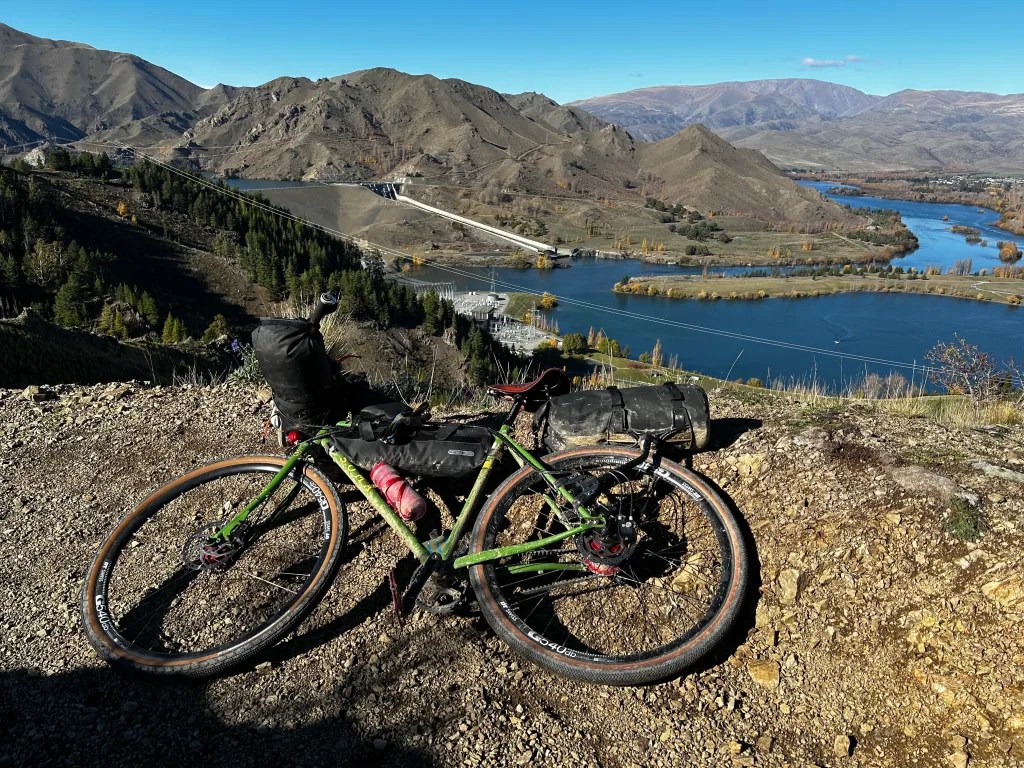


I decided to film going over the first section of the dam:
Having successfully crossed the dam, I stopped for lunch in perfect weather and with a million dollar view. It was here I had the one mishap of the entire trip – for some reason I put my gloves on the bag on the back of my bike (probably to let them dry a bit in the sun). I knew there was a steep and fast descent to start which I was looking forward to and, inexplicably, I forgot to put my gloves on. After zooming 2-3km down the valley below the dam I realised I’d left my gloves sitting on the back of the bike. At that point, there was no way I was going to bike back up that hill to retrieve them! Following down the northern side of the river I enjoyed the solitude and observed many camping grounds alongside the river – clearly this is a very popular place for holiday makers in the summer.
Eventually I reached the Aviemore Dam – the little brother to Benmore, and crossed over this back to the southern side of the Waitaki River and back into Otago District. At this point I came across a beautiful old abandoned building from yesteryear:

From here, it was a short ride down to Kurow, hometown of Richie McCaw the former All Black captain who was honoured by a 5m sign in the small town. I checked into the holiday park and headed to the pub to watch the Crusaders rugby game!


Day 9 – Kurow to Oamaru (A2O route)
- Moving Time: 4hr 19 min
- Distance: 77.76km
- Elevation: 621m
The final day of riding dawned quite chilly and, with my gloves being lost, I was going to have to overcome the numb fingers and charge on to the finish line. Concerningly, the ride was over before it almost began because as I entered the trail there were signs saying it was shut due to the duck hunting season kicking off that weekend:

As I was pondering whether to chance it, a local walking her dog reminded me there were likely to be “cowboys” shooting ducks down on the wetlands near the river that the trail traversed and I would be infinitely safer taking SH83 towards Duntroon and joining the trail further along. Heeding this wise advice, I headed off down the road, doing a comfortable 32kph with the downhill gradient feeling the full effect of the 6 degrees temperature on my fingers! After 15km or so I was able to rejoin the trail as it simply ran alongside the road heading towards Duntroon, but not before I checked out the Māori cave art on the way which was pretty cool. The pictures don’t really do them justice as the lighting was poor but it was cool to see this part of our history:


Shortly after I arrived in Duntroon and bought a sandwich to have for lunch later from the Flying Pink Pig cafe, and then checked out the historical gaol:


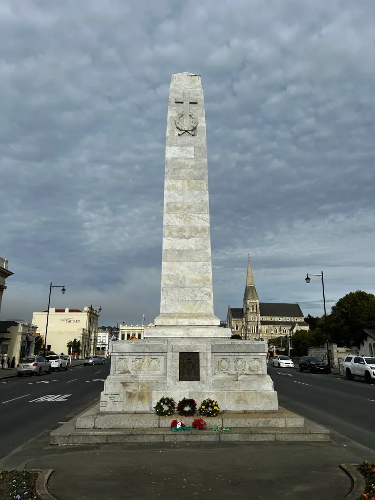
There was also a beautiful memorial to the local men who had fought overseas, many not returning. Across the road, and in fact at major trees further along the route, there were also white crosses with the name of an individual represented on the main cenotaph at the base of each tree. I reflected on this quite a lot over the remainder of the ride, and concluded it was a nice gesture to plant something living as a memorial to someone who had passed away on foreign shores.


Heading directly south for a while there were some interesting rock formations, including the “elephant rocks” that were once below sea level but now stood at over 220m above sea level – how things changed! According to the signboard, these were part of a scene in the Chronicles of Narnia that was filmed in the region in 2005.


Despite the impression I should be riding “all downhill” at this point, there were a couple of sneaky climbs remaining and I leaned into these keen to finish and also keep warm as it was still quite chilly. I was rewarded with one final unexpected feature – the Rakis Tunnel. I was pleased my bike has a dynamo generated front light that detects lowlight and turns on automatically, but I did stop and also put on my headlamp I keep in the framebag for moments such as this! It was a remarkable piece of engineering, curving through the hillside and lined with stone throughout:


This segment was full of big skies, big mountains and big pastures, all of which made for enjoyable riding:
Pretty soon, it was evident I was on the outskirts of Oamaru and I enjoyed the sense of finality that comes from achieving something pretty cool. The Alps 2 Ocean route has done a good job of showing off some of the best of Oamaru in a short sprint to the end, riding through the beautiful Botanical Gardens and then on through the historical precinct. I paused briefly to snap a shot of my bike beside the beautiful water fountain in the gardens and also of a church that was pealing out Sunday bells as if to mark my arrival and completion of the A2O:


And then almost before I knew it, I was finished. Done. At Oamaru harbour front and asking a stranger to take a photo of me in the finishing “photo frame”:

As if on cue, the sun came out, the wind turned warm, and the gentle lapping of the tide seemed to herald my arrival and congratulate me on my efforts. I felt well pleased with myself, having biked nearly 600km from Christchurch, inland towards near Mt Aoraki/Cook and then all the way back down to the sea. My trusty Soma Wolverine bike had performed flawlessly, no punctures/flats and the only maintenance it needed was brief splash of water at Omarama to wash off some of the mud. Similarly, my tent, sleeping mat and quilt had been excellent in keeping me warm and dry and I got the distinct impression that I could have easily kept going if I’d wanted to and had the opportunity to do so.
I took a short video of the tide lapping the edges of the beach in a cathartic end to my ride:
Feeling euphoric and rather hungry, I wandered across the road to the brewery bar that had a live band playing in the garden and promptly ordered some delicious bao buns and fries!


Hoping to reward myself with a sleep in a cabin at the holiday park beside the Botanical Gardens, I was out of luck as they were full and had to instead spend the final night in my tent as another deep mist settled over the township of Oamaru.
Day 10 – Oamaru (and home)
Given I’d had a rest day in Lake Tekapo I did not really have the opportunity to push on to Dunedin and meet my wife and daughter there, so instead decided to just cruise around Oamaru checking out some of the sights. Breakfast was pretty high on the priority and I decided there might be something yummy in the old precinct and so it turned out.
It’s such a unique area and if you’re in the region I highly recommend exploring it as you feel taken back to the 19th century:


There were numerous obelisk honouring their war dead as well, this time in prominent locations on the main road. I’d imagine these would have been erected at considerable cost at the time but it is easy to see why and how important it would have been for the local communities to remember their boys that never made it home.


Oamaru is also know as “steam punk central” with numerous artworks around the area depicting some interesting features of this unusual genre. It’s not a great photo from a lighting perspective, but this was one of the more impressive artworks:

Finally, it was nearly time to go home. I had a call from my wife saying they were enroute from Dunedin so I returned to the campsite and unloaded my bike of the various bikepacking bags – it looked somehow naked with these all removed, but a necessary evil to ensure nothing flew off the bike when it took the 3hr drive home to Christchurch on the roof of the car!

Final Reflections
Overall, this was a tremendous trip and one that I felt was very successful.
I was not setting any pace or distance records each day, but felt I was going at a pace that I could easily have sustained almost indefinitely and I quickly fell into a pleasant routine of setting up/down camp each day, biking for 3-6hrs a day and then enjoying the sense of newness in being somewhere different each day.
Choosing to stay in holiday parks made it relatively easy to maintain momentum – I could do a wash of cycling clothing every two days, resupply at local supermarkets easily enough and, when I felt I needed a better night sleep, could stay in a bed in a basic cabin if needed. Interestingly, however, I was gaining many new efficiencies and tips each day both in terms of my set up/down of my camping gear, but also in better refining my sleep system – lowering pressure in the air mattress and pillow, and in the end even substituting the pillow for my puffer jacket as a makeshift pillow I could shape and mould as needed.
I generally do not like wearing ear plugs at the best of times, but given the windy and rainy night I’d had in Lake Tekapo, I bought some from the pharmacy in Twizel and this made a measurable improvement to my sleeping in the tent and something I’d likely persevere with moving forward.
One interesting learning was I did not use my JetBoil once – I definitely cooked some meals and made hot chocolates to drink but did so in the holiday park kitchen, rather than “on the go” – depending on future routes, I think I could likely leave this behind if I was anticipating staying in holiday parks instead of the bush or very basic DoC campsites. One of the best things of being in a holiday park is being able to have a hot shower at the end of a day on the bike – worth the price of admission for sure!
And so ends my Redundancy Ride and, equally important, my redundancy period. I start a new role on Monday 15th May and can’t wait to get back into the realm of the working. However, this was an outstanding way to spend 10 days and I consider myself very fortunate and blessed to have been able to do so.